UPDATE: TODAY - 9.30AM THURSDAY, 29 FEBRUARY
The forecast Extreme Fire Danger conditions forecast for Wednesday, 28 February have now passed.
For anyone who lives in an area covered by a Watch and Act, it is still not safe to return home. Continue to monitor the VicEmergency app and website for updates.
Anyone within the area of the potential impact map who is not under a Watch and Act can now return home and resume normal activities.
***
TUESDAY, 27 FEBRUARY
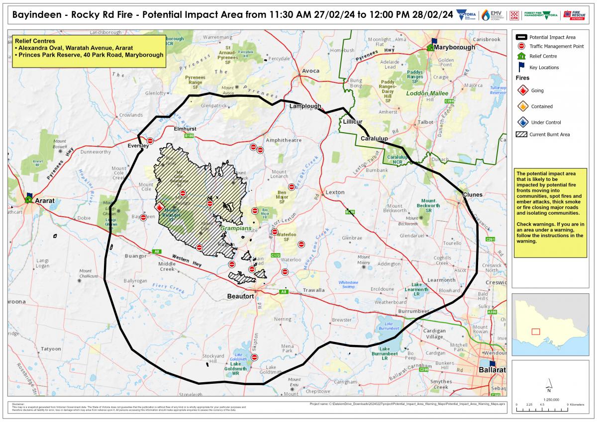
People in the areas surrounding the Bayindeen bushfire (identified in the map below) should leave their homes early – on Tuesday 27 February or before midday Wednesday 28 February – before Extreme Fire Danger conditions put you at significant risk.
Who is this message for
This information is for everyone located in the area of Ampitheatre, Beaufort, Clunes, Elmhurst, Learmonth, Lexton and surrounds.
What we know
The bushfire that started in Bayindeen on Thursday, 22 February is not yet under control and remains active.
An Extreme Fire Danger Rating has been declared for the South West weather district on Wednesday 28 February.
Temperatures in the high 30s have been forecast in the area by the Bureau of Meteorology, along with gusty winds of 60-80km/h.
With these conditions forecast, the fire could spread quickly and be extremely dangerous.
These locations are expected to be impacted by fire, spot fires and ember attacks or the fire may close major roads resulting in isolated communities.
What we want you to do
Anyone in these areas should leave early – leave Tuesday 27 February or early Wednesday 28 February. Do not travel to these areas.
Do not wait until the bushfire spreads closer before moving to a safer location. The Bayindeen fire could grow significantly and may become uncontrollable.
If you do not leave today, you may become isolated and your route to safer locations may be blocked. Road closures may occur, including roads that have recently been reopened, if they are threatened or impacted by fire.
Do not rely on firefighting crews to protect you and your property.
Where you can go
If you are in the Ampitheatre, Beaufort, Clunes, Elmhurst, Learmonth, Lexton and surrounds area, move to a built up area like Maryborough, Ararat or Ballarat or another regional city outside the potential impact area.
These are areas that have been identified as defendable by emergency services.
Relief centres are open:
- Ararat: Alexandra Oval, Waratah Avenue
- Maryborough: Princes Park Reserve, 40 Park Road
Major road closures include:
- Pyrenees Highway
- Lexton-Ararat Road
- Beaufort-Lexton Road
- Amphitheatre Road
- Eurambeen-Raglan Road
- Main Lead Road
Emergency services will advise when it’s safe to return or travel to family and friends who are outside the area.
Before you travel, check that your planned route and destination are not currently under threat from fire. Do not travel into areas of Extreme or Catastrophic Fire Danger.
While travelling, monitor weather conditions by listening to local or ABC radio as conditions may change quickly.
Take care on the roads and drive to the conditions. Smoke from these fires may impact visibility when driving.
How you can prepare
When you leave, take the following items with you:
- Cash
- Clothing for three days
- Medicine for three days
- Phone and chargers
- Toiletries
- Important documents
- Mementos and photos
- Pets essentials, including leash and carriers
- Make sure you have enough petrol in your car
Further information to help you
If you have left, ensure you register with Register.Find.Reunite online: www.register.redcross.org.au – Extreme Weather Western Victoria 2024.
This service lets people know you are safe, that you have relocated away from the area, and is used by emergency services if evacuations are required. People leaving early, or who relocate from the fire area, are asked to register as soon as possible.
If you are in any area with a Catastrophic or Extreme Fire Danger Rating, it is critical that you monitor warnings and stay informed. You should follow the instructions of emergency services.
Check VicEmergency for warnings frequently. If you are currently in an area that is under a warning you must follow the instructions in that warning.
Potential impact area:
The map below shows the potential impact area for the Bayindeen fire. This is based on current modelling and forecasting and is current from 10am Tuesday 27 February to midday Wednesday 28 February.
